|
Page
|
|||||
|
TABLE
OF CONTENTS
|
2
|
||||
|
LIST
OF FIGURES
|
2
|
||||
|
1.
|
INTRODUCTION
|
3
|
|||
|
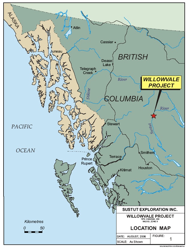
2.
|
LOCATION/ACCESS/TOPOGRAPHY
|
4
|
|||
|
3.
|
PROPERTY
DESCRIPTION
|
6
|
|||
|
4.
|
HISTORY
|
8
|
|||
|
5.
|
REGIONAL
GEOLOGY
|
9
|
|||
|
6.
|
PROPERTY
GEOLOGY
|
12
|
|||
|
7.
|
SOIL
GEOCHEMICAL SURVEY RESULTS
|
13
|
|||
|
8.
|
ROCK
SAMPLE RESULTS - WILLOW PROPERTY
|
14
|
|||
|
9.
|
CONCLUSIONS
|
16
|
|||
|
10.
|
RECOMMENDATIONS
AND COST ESTIMATES
|
17
|
|||
|
11.
|
STATEMENT
OF QUALIFICATIONS
|
18
|
|||
|
12.
|
REFERENCES
|
19
|
|||
|
Figure
1. Location
Map
|
5
|
|
Figure
2. Claim /
Topographical Map
|
7
|
|
Figure
3. Regional
Geology
|
11
|
|
Figure
4. Rock Samples
Location Map
|
15
|
|
1.
|
Introduction
|
|
2.
|
Location/Access/Topography
|
|
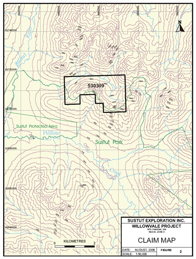
3.
|
Property
Description
|
|
Claim
Name
|
Claim
Size (Ha)
|
Record
#
|
Expiry
Date
|
|
Willow
|
445.70
|
530309
|
December
13, 1997
|
|
N.B.
|
The
moniker Willowvale project is used interchangeably with Willow property,
the actual claim name.
|
|
4.
|
History
|
|
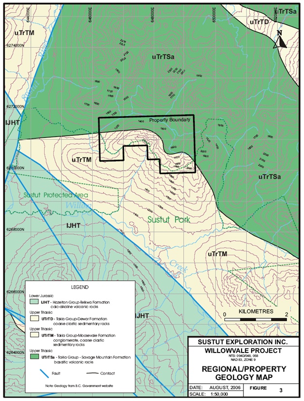
5.
|
Regional
Geology
|
|
6.
|
Property
Geology
|
|
7.
|
Soil
Geochemical Survey Results
|
|
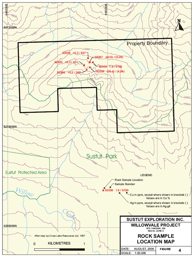
8.
|
Rock
Sample Results - Willow
Property
|
|
Sample
No.
|
Cu
(%
or ppm)
|
Ag
(g/t
or ppm)
|
Description
|
|
92004
|
4.94
%
|
35.4
g/t
|
Grab,
Willow showing, Diss. Bornite in shale. Outcrop. Elev = 1,635
metres
|
|
92005
|
451
ppm
|
<0.2
ppm
|
Grab,
silicified green mafic tuff. Diss. Py, Aspy?
|
|
92006
|
245
ppm
|
<0.2
ppm
|
2
metre chip. Pyritic tuffaceous sediments. Elev = 1,675
metres
|
|
92007
|
6.28%
|
44.8
g/t
|
Grab
of float boulder, trace bornite. Argillic seds. Elev = 1,550
metres
|
|
92008
|
467
ppm
|
<0.2
ppm
|
Grab
silicified shears CPY, mal in 10-15 cm shears, 10 metre talus boulder.
Elev = 1,400 metres
|
|
92009
|
6,169
ppm
|
1.6
ppm
|
Grab
float boulder. Mal Stained green mafic
tuff
|
|
9.
|
Conclusions
|
|
10.
|
Recommendations
and Cost Estimates
|
|
Item
Description
|
Cost
Estimate
|
|
Helicopter
support (6 hrs x $1,000/hr)
|
$6,000
|
|
Labour
(2 tech. x 7 days @ $350/day)
|
$4,900
|
|
Sample
Analyses (100 soil + 50 rock @ $30/sample)
|
$4,500
|
|
Room
and board
|
$2,000
|
|
Mob./Demob.
+ truck + fuel
|
$3,000
|
|
Report
and drafting
|
$5,000
|
|
10%
contingency
|
$2,500
|
|
Total
|
$27,900
|
|
|
ROUNDED
= $30,000
|
|
11.
|
Statement
of Qualifications
|
|
1.
|
I
am a graduate of the University of British Columbia with a degree
in
Geology (B.Sc., 1986);
|
|
2.
|
I
have practiced my profession as a Geologist continuously since graduation;
|
|
3.
|
I
am a director of Nicholson and Associates Natural Resource Development
Inc., a private geological consulting company, and a director of
United
Exploration Management Inc., a private resource management and research
company;
|
|
4.
|
I
am a member of the Association of Professional Engineers and Geoscientists
of the Province of British Columbia (No.
19796);
|
|
5.
|
I
am a Fellow of the Royal Geographic Society (No.
423161);
|
|
6.
|
There
are no material facts or material changes in the subject matter of
this
report that would mislead the
reader;
|
|
7.
|
I
have no interest, direct or indirect, in the properties or common
shares
of Sustut Exploration Inc., nor do I expect to receive
any;
|
|
8.
|
I
have prepared this summary report from existing public files and
from my
own knowledge of working in the area;
and,
|
|
9.
|
I
hereby grant my permission for Sustut Exploration Inc. to use this
Report
for any corporate use normal to their
business.
|
|
12.
|
References
|